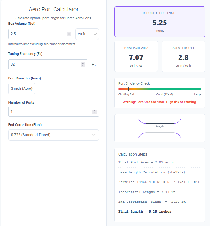
Sometimes, the shape you need to measure isn't a perfect square, circle, or triangle. It's a rough sketch of a garden, a satellite map of a farm, or a blueprint of a room. The Draw Area Calculator is a browser-based CAD tool that lets you trace any shape over an image or draw freely to calculate area instantly.
Think of it as a digital planimeter. Instead of struggling with complex geometry formulas for irregular shapes, you simply define the boundary, set the scale (e.g., 'this line is 10 meters'), and the tool computes the area inside. It's perfect for measuring objects from photographs, maps, or technical drawings without installing heavy software.
Features of Sketch & Calculate Area
This tool combines the ease of MS Paint with the precision of vector engineering software.
Image Upload & Trace: Drag and drop any image (JPG, PNG) onto the canvas—a Google Earth screenshot, a floor plan, or a drone photo. The image becomes your background layer, ready for tracing.
One-Click Calibration: Draw a line over a known distance (like a scale bar on a map or a wall you measured) and tell the tool 'this is 50 feet'. It instantly sets the scale for the entire canvas, analyzing every pixel's real-world size.
Multi-Layer Management: Just like professional CAD, you can create multiple layers (e.g., 'Lawn', 'Patio', 'Pool'). Each layer can have its own color and visibility, and the tool sums up the total area of all visible layers.
Polyline & Freehand Tools: Use the 'Polygon' tool for precise, straight-edged shapes (click-click-click) or the 'Freehand' tool to trace organic, curved shapes like lakes or flower beds.
Smart Unit Support: Work in the units that match your project. Calibrate in feet but view results in Acres? No problem. It supports Meters, Feet, Inches, Centimeters, Kilometers, Acres, and Hectares.
Live Area Summation: As you draw, the 'Total Area' updates in real-time. Toggle layers on and off to see area combinations (e.g., 'Total Lot' minus 'House Footprint').
How to Use Draw Area Calculator
- Upload Reference: Drag your plan/map image onto the grid.
- Calibrate: Select the 'Calibrate' tool (ruler icon). Draw a line along a known dimension. precise input box appears—type the real length (e.g., '10') and unit.
- Trace: Select the 'Polygon' tool. Click around the perimeter of the area you want to measure. Double-click to close the shape.
- Organize: Click '+' in the properties panel to new layers for different sections (e.g., Layer 2 for 'Driveway').
- Read Result: The total area is displayed in the bottom right. Use the dropdown to switch between Sq Ft, Sq Meters, Acres, etc.
Common Applications
This visual approach to area calculation is indispensable for:
- Landscaping & Pavers: Take a drone shot of a backyard, set the scale using a known fence length, and trace the lawn to know exactly how much sod or mulch to order.
- Real Estate & Land Surveying: Quickly estimate acreage from a property plat map or satellite view without needing on-site laser measurements.
- Construction Take-offs: Contractors can upload blueprints and trace rooms to estimate flooring, painting, or drywall material quantities.
- Scientific Research: Biologists use it to measure the area of leaves, bacterial colonies, or microscopic features from lab photos.
Frequently Asked Questions (FAQs)
Q: How accurate is image tracing?
A: Accuracy depends on your calibration. If you calibrate a long line (e.g., a 100ft property line) rather than a short one, your results will be highly accurate (typically within 1-2%).
Q: Can I save my drawing?
A: Currently, the tool runs in your browser's memory. You cannot save the project file, but you can take a screenshot of your work with the calculated data visible.
Q: Does it handle curved lines?
A: Yes. The 'Freehand' tool allows you to draw curves. Also, you can approximate curves with the Polygon tool by making many short clicks along the edge.
Q: What image formats are supported?
A: It supports standard web image formats: JPEG (.jpg), PNG, WEBP, and GIF.
Q: How do I subtract an area (like a pool from a lawn)?
A: Create a new layer for the 'Pool', measure it, and note the area. Then subtract that number manually from your 'Lawn' layer total. (Future versions will support boolean subtraction).
Final Words
The Draw Area Calculator transforms your screen into a powerful measuring table. By breaking the barriers of fixed shapes and allowing you to interact directly with visual plans, it saves hours of mental math and estimation. Whether you are pricing a driveway job or measuring a patch of forest on a map, 'Draw, Calibrate, Calculate' is the modern way to get the job done.