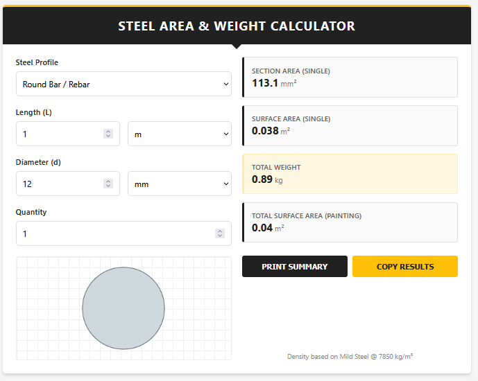
The Map Area Calculator is a powerful geolocation tool that allows you to calculate the area of any place on Earth by drawing on a satellite map. Instead of relying on manual measurements, this tool uses GPS coordinates and geodesic math to determine the surface area of fields, roofs, parks, or cities.
It is essentially a "Google Earth" style planimeter in your browser, perfect for measuring things that are too large to measure with a tape.
Features
1. Interactive Mapping: Uses a high-resolution satellite map (Leaflet) that lets you zoom in anywhere in the world and drop pins to outline a boundary.
2. Geodesic Accuracy: Unlike simple 2D map tools, this calculator accounts for the curvature of the Earth, providing survey-grade accuracy for large areas.
3. Search & Locate: Includes a search bar to jump instantly to an address (e.g., "Central Park, NY") and a "My Location" button to zoom to your current GPS position.
4. Multiple Units: Instantly converts the drawn area into Acres, Hectares, Square Meters, Square Feet, and regional units like Guntha and Bigha.
5. KML Export: Lets you download the shape you drew as a KML file, compatible with Google Earth and other GIS software.
Uses
- Agriculture: Measuring farm acreage for crop insurance or seed buying.
- Real Estate: Checking the land area of a property from the comfort of your desk.
- Solar Energy: Estimating the available roof area for solar panel installation.
- Urban Planning: Measuring parks, parking lots, or development zones.
Tips
- Zoom In: For the best accuracy, zoom in as close as possible before dropping your boundary pins.
- Close the Loop: To finish drawing a shape, click back on the very first point you created. The tool will automatically calculate the area once the polygon is closed.
- Satellite Mode: Switch to "Satellite" view using the layer control to see fences, treelines, and buildings clearly.
FAQs
How accurate is GPS area?
It depends on the map resolution. Generally, it is accurate to within 1-2% for larger plots (over 0.1 acres). For very small garden beds, a tape measure is better.
Does it measure roof slope?
No. Map tools measure "Planar Area" (the footprint). If your roof is sloped, the actual surface area will be larger (multiply by the pitch factor).
Can I measure distance too?
Yes, the tool calculates and displays the total Perimeter (distance around the edge) alongside the Area.
Final Words
Forget measuring wheels and long tapes. With the Map Area Calculator, the entire world is your canvas. Whether you are a farmer, a realtor, or just curious, measuring land has never been this accessible.